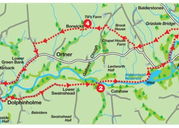
Weekend Walk: Dolphinholme


A superb route exploring the Wyre Valley.
Directions: From the car park turn right, pass the church and then Church Close to turn right into the next close. Take a footpath to the left of an arched entrance and descend to Lower Dolphinholme. Turn right onto Wagon Road. After passing through the settlement continue on the lane for 500yds.
As you reach a bend take a farm track left following the direction of a marker post confirming you are on the Wyre Way. Follow the track as it drops to a depression and then sweeps right to arrive at a metal gate. Through the gate the track becomes grassier as it continues across a broad field. After the next gate keep ahead with the fence line to the right. Maintain this direction crossing large pastures to reach a kissing gate before a stone barn. Pass the barn and at the next stile next to a metal gate bear left on a path leading to another metal gate. Through this continue to a wooden gate leading into woods. Follow the path down to the River Wyre and a substantial footbridge.
Advertisement
Hide AdAdvertisement
Hide AdCross the bridge and turn right. Although slightly off the right of way you may wish to take advantage of a broad farm track to the left which leads up the lovely valley. 15 minutes walking will bring you to a nondescript utility building. Hard to believe this was the scene of one of the worst accidents in the history of Lancashire. A memorial nearby attests this was the site of the Abbeystead Disaster May 23, 1984.
Continue past the building and then take a footpath on the right through a kissing gate. This leads into lovely woods above the Wyre. Follow the path as it brings you to the dam end of Abbeystead Reservoir. Keep on a track through a wooden gate as it leads up towards a large woodyard. Just as you reach it turn right through a wooden gate cross a field to its far right corner to arrive on the Rake. Turn right on the lane to pass through the estate village of Abbeystead. Just before reaching the river at Stoops Bridge turn left onto the Wyre Way. Follow the broad track for half a mile to Lee Bridge by Rakehouse Brow.
This marks the start of the return leg. Turn left and immediately left onto a footpath leading steeply uphill to a footbridge. The way now traverses a boggy pasture to a stile. After this follow the hedge line on the left . 50 yrds after a wooden gate on the left cross a stile and continue on a broad track with the hedge on the right. Keep ahead crossing a depression to reach Abbeystead Lane. Cross this to a stile and then bear left to the field corner. As you arrive close a road corner turn right on a path leading up to Chapel House Farm. Go through the farm buildings to enter a broad upland pasture. Follow the fence on the left to a corner and then bear left to a stile near a gate. From here keep ahead to a metal gate. Through this cross to the footbridge below Meeting House farm with its Quaker burial ground. At the farm take its drive Plantation Lane and turn left. After 150yds turn right on a path that diagonally crosses a pasture to a wall corner and then picks up a track leading to Borwicks Farm.
Pass the farm on your right and then descend to a footbridge in a wooded clough. On the far side cross a stile and then aim for a stile with a tall post. Keep ahead with a wall to the right. After the next stile the path drops into a big valley to cross a footbridge by a wall and then climb the large pasture beyond. After the next stile close to the brow keep ahead to a stone stile over a wall. Continue with the hedge on the right to reach a farm. After the house turn right through a gate to access its drive. Once on the lane turn left. Into 250yds turn right onto Abbeystead Road to reach Dolphinholme in another mile.
Advertisement
Hide AdAdvertisement
Hide Adl Walk devised by David Sherwood Johnstone organiser of the Saunders Lakeland Mountain Marathon and described by Bob Clare of www.lancashirewalks.com.
l Bob’s book, ‘100 Walks in Lancashire’, published by Crowood Press, will be available from many local booksellers next month.
__________________________
Start: Dolphinholme Village Hall
Distance: 8 miles, 13k
Time:3½-4½ hours
Summary: Moderate
Map: OS OL41 The Forest of Bowland