An ideal introduction to the joys of the countryside


Three weeks from now sees the start of the Garstang Walking Festival. Between Saturday, May 5 and Sunday, May 13, a large number of guided walks have been arranged from a range of different venues across Wyre Borough led by countryside rangers and volunteers. The festival was launched by Wyre Council to encourage people to visit its lovely countryside. This year the theme is ‘Moss, Meadows and Moorland’ highlighting the fact that the River Wyre, the longest river to flow entirely through Lancashire, links the high hills of Bowland with Morecambe Bay offering the outdoor enthusiast a rich variety of habitats to explore. Walks are graded from those which all abilities can easily accomplish (flat, surfaced paths, no stiles and suitable for wheelchairs and buggies) to the very hard (limited paths, rough walking and steep climbs). Participants will need to have stout footwear or walking boots, all weather clothing and for longer walks a packed lunch and drink. In the programme 20 venues are listed offering over 40 guided walks or health walks (which are provided throughout the year.) Health walks and short walks lasting up to an hour are free. Half day walks cost £3.50 (concessions £2.50). Full day walks cost £4.50 (concessions £3.50) see the programme on www.wyre.gov.uk website. For booking enquiries phone 01995 602125. I know many readers like the concept of walking but are hesitant to give it a go. Even the wonderful walks described in this column week after week fail to induce them to take those first steps into the great outdoors. Well, Garstang Walking Festival with its programme of walks to suit every ability is an ideal introduction to the simple and beneficial joys of countryside walking. For the more experienced I draw your attention to a two day practical course ‘Introduction to Map and Compass’ which aims to develop navigational skills including a short walk (three miles) allowing participants to apply the skills taught on the course. The walk described below is not directly connected with the festival but starts at one of its venues and is offered as a taster of what might be expected. Though no great distance this circuit packs a lot in taking you through a delightful valley and up onto the summit of one of Lancashire’s most prominent viewpoints.
WALK FACTS
Start: Scorton Village Centre, PR3 1AU
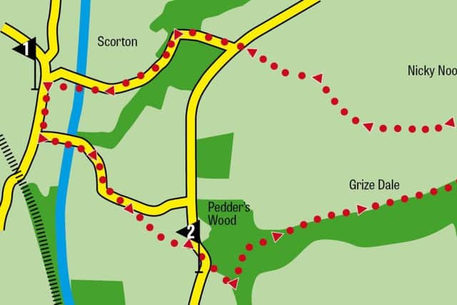
Distance: 3.6 miles/5 ½ k
Time: 2-2 ½ hours
Summary: Mainly easy but involves a steep climb out of Grizedale
Map: OS OL 41, The Forest of Bowland
DIRECTIONS
Advertisement
Hide AdAdvertisement
Hide Ad1.From the centre of the village walk south on the main road (Gubberford Lane). After the church on the left turn left into Tithe Barn Lane. After passing under the M6 motorway continue as the road bends to the right and then more sharply left climbing uphill. A quarter of a mile after the motorway bridge turn right onto a footpath accessed on a drive. This path cuts a corner as it takes you across meadows to Slean End on Higher Lane. Turn right and almost immediately take a footpath on the left leading into Grizedale.
2. Grizedale is simply one of the loveliest valleys in Lancashire - and therefore the whole world! At this time of the year its flanks are bedecked with bluebells. Look out for deer as the woods here provide an ideal habitat for them. The path leads across a broad open space. At a footbridge turn left and keep ahead on a good track for just under a mile. 400yds beyond the dam end of Grizedale Reservoir on your right turn left onto a narrow footpath leading to the summit of Nicky Nook.
3. The path is steep but soon breasts the plateau with the trig point obvious before you. Though not high even by Lancashire standards - just over 700ft above sea level - because of its relative isolation from other high hills Nicky Nook is one of the best viewing platforms in…you get my drift! Out to the west stretches the Fylde with Blackpool Tower easily made out on the coast. To the north is Morecambe Bay providing foreground for the Lakeland Hills. At your feet the M6 and the main West Coast railway - great commercial arteries of the nation - drivers and passengers passing below unaware of the adventure this modest hill has given you. I wax too lyrical - time to move on. Follow the broad grassy path head northwest keeping to the left of The Tarn. After a wall junction the path leads steeply downhill to reach a junction of Higher Lane with Snowhill Lane. Go straight ahead into Snowhill Lane for the village centre.
- Friends of Garstang Walking Festival: This voluntary group was formed to support the Countryside Ranger team in organising and coordinating the Festival. Call Les on 01995 672230 for more information. Every credit should be given to the Friends and Rangers for their dedication and time in creating a first class Lancashire event.